
Driving Minnesota's Best Scenic Byway: North Shore Scenic Drive, an All-American Road
- Greg Phillips
.JPG/v1/fill/w_320,h_320/file.jpg)
- Mar 29, 2024
- 5 min read
Updated: Apr 30, 2025
This byway is one of our choices for Minnesota’s Top Scenic Byways, as listed in our Minnesota section.

It’s time to start planning summer road trips and Minnesota has some of the best options in the US. One of my favorite scenic byways follows Lake Superior from Duluth north to the Canadian border. Lake Superior is massive, offering ocean-style views without the fishy, seaweed smell of the sea. The water is cold and the beaches are rocky so don’t expect a Florida experience, however. Instead, think high bluffs overlooking the water, thick forests and lots of waterfalls. There are numerous state parks along the route, too, providing hiking, camping, kayaking and many other outdoor activities. Or you can just drive the highway and enjoy the pullouts, Split Rock Lighthouse and candy at Beth's Fudge and Gifts in Grand Marais.

Duluth northeast to Grand Portage and the Canadian border
Distance: 150 miles / 241 km
Driving north of Minneapolis/St. Paul on I-35, it’s 2.5 hours to one of Minnesota’s most enticing cities and the start of the state’s best byway – an All-American Road to boot. Duluth is strategically located at Lake Superior’s westernmost point, where the St. Louis River flows into the lake, forming the border with Wisconsin. Copper, iron ore and lumber along with the railroad made Duluth a major shipping hub. In fact, in the early 1900s the port was busier than New York, handling more cargo tons annually than the Big Apple. After falling on hard times, the city has made a comeback with a thriving art and music scene, hip restaurants and breweries and numerous museums. Other notable attractions include the Great Lakes Aquarium, North Shore Scenic Railroad with rides along Lake Superior and the Aerial Lift Bridge, the world’s biggest and fastest lift bridge.
There are several outdoor outfitters in the city, too, attesting to Duluth’s connection to nature. It’s the gateway to almost any freshwater activity you can dream up with North Shore Scenic Drive providing the main access. Stretching 150 miles from Duluth to the Canadian border, the route features eight state parks and five waysides with hiking, camping and water recreation.
Following the Lake Superior shoreline and heading northeast, I-35 quickly becomes Minnesota State Highway 61. About 6.5 miles out of Duluth, be sure to stay on old MN 61 instead of the four-lane freeway. The two-lane route provides beach access and water views with less traffic. Along the drive, cozy motels, cafes, art galleries and Russ Kendall's Smokehouse, famed for its smoked fish, give the byway a local flavor.
From Duluth, the first big town you’ll come to is Two Harbors. After Duluth, it’s the second largest community on the byway. Snuggled between Agate Bay and Burlington Bay, the town is a working port with beaches, camping and a couple of interesting historical attractions. Two Harbors Lighthouse is the oldest operating lighthouse in Minnesota. Anchored in the water nearby is the Edna G. Built in 1896, she was one of the most powerful tugboats of her time. And every Thursday evening throughout the summer, the Two Harbors City Band, Minnesota’s oldest continuously operating city band, plays under the bandshell in Thomas Owens Park.
The headlands, cliffs, pebbly beaches and thick forests on this road trip really begin to shine beyond Two Harbors. Old and new MN 61 merge to become one highway that climbs bluffs and passes through tunnels. From the various overlooks, massive Lake Superior looks like an ocean, but its crisp, clean smell is that of the world’s largest freshwater lake by surface area. By comparison, the saline Caspian Sea is earth’s largest lake and Russia’s Lake Baikal is the world’s deepest freshwater lake. Formed by volcanoes and glaciers, Lake Superior contains more water than the other four Great Lakes combined, so big it has its own weather patterns.
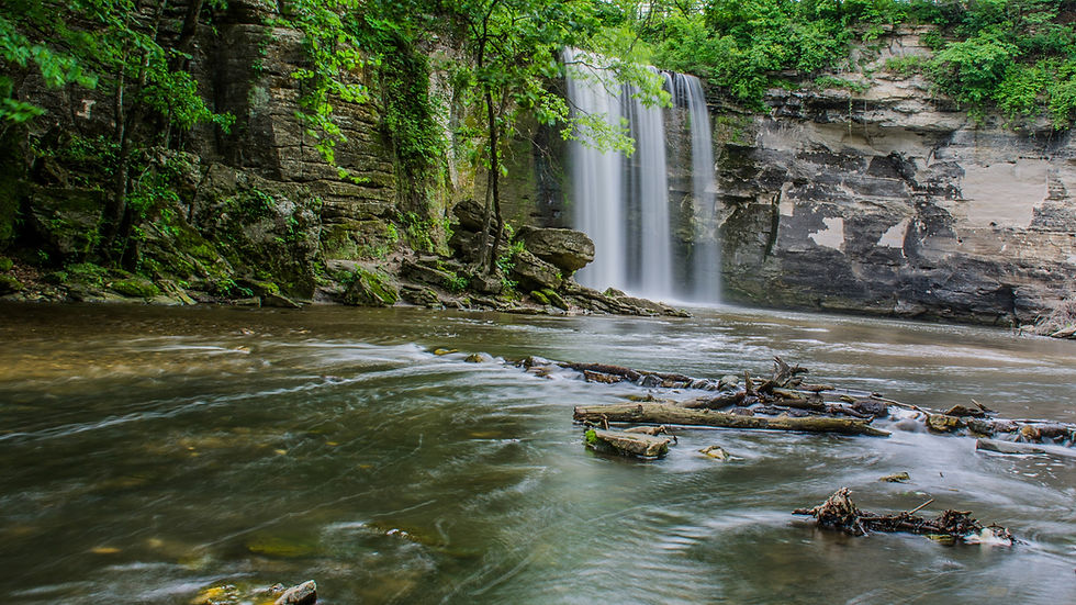
More than 200 rivers feed Lake Superior and in Minnesota this means a lot of waterfalls. From Two Harbors, it’s 13 miles northeast to Gooseberry Falls State Park with a campground, several hiking trails and five waterfalls.
From Gooseberry, it’s just seven more miles to Split Rock Lighthouse State Park. While the shoreline, lake views, hiking trails and camping are highlights, the star is the lighthouse. Perched on a cliff and offering tours, the stately 1909 lighthouse is one of the most photographed sites in Minnesota.
From Split Rock, Tettegouche is the next state park and you’ll want to stop first at Palisade Head, about 11 miles from Split Rock. This chilling feature isn’t for those who fear heights. Palisade Head is the highest cliff on Lake Superior, plunging 300 feet to the water below. There’s no fence or rail. Rock climbers fearlessly scale the walls, adding to the intensity. It’s another two miles up MN 61 to the main part of Tettegouche State Park with more campgrounds, trails and waterfalls. The steep lake overlooks and beaches are particularly gorgeous.
After Tettegouche another sting of pretty parks extend up MN 61: George Crosby Manitou State Park, Caribou Falls State Wayside, Temperance River State Park and Cascade River State Park. So, there are plenty of options for camping, fishing, kayaking and hiking on busy summer weekends and holidays.
Grand Marais is the next major town, 50 miles from Tettegouche State Park. Geared to tourists, Grand Marais has crafts, coffee, ice cream, lodging and an attractive boat-filled harbor.
Grand Marais is also the start of another inspirational road trip, the Gunflint Trail Scenic Byway. This 56-mile one way trek on paved County Road 12 goes away from Lake Superior and deep into Minnesota’s North Woods. The byway passes through the highest parts of Minnesota with countless lakes, endless trees and lots of potential wildlife sightings. Watch out for moose. The road dead ends at Trail's End Campground and the Boundary Waters Canoe Area Wilderness, just a short distance from Canada.
Back in Grand Marais and following Lake Superior northeast, North Shore Scenic Drive is now in the heart of Superior National Forest, where woodlands run to the edge of the Great Lake. From Grand Marais it’s 14 miles to Judge C.R. Magney State Park where a two-mile roundtrip hike leads to Devil’s Kettle, a remarkable waterfall where half of the cascade disappears into a hole after flowing around a large outcropping.
From Judge C.R. Magney, it’s 21 miles on MN 61 to Grand Portage National Monument. The Canadian border is just a few minutes farther. Situated in the present-day homeland of the Grand Portage Anishinaabe, the monument preserves a major fur trade area from the late 1700s. As the National Park Foundation notes, “Before the United States and Canada existed, the trading of furs, ideas and genes between the Ojibwe and French and English fur traders flourished.” The monument is a living history museum with interpreters and demonstrations. Housing more than 100,00 objects, it includes an impressive re-creation of the North West Company Depot as well as native Anishinaabe artwork and a collection of canoes. In August, the monument hosts Grand Portage Rendezvous Days. The free two-day event is open to everyone and includes music, dancing, craft demonstrations and hands-on workshops. And you’re not required to wear period clothing! At the same time, the Grand Portage Band hosts a powwow within walking distance of the monument.
Grand Portage is also a launching point to Michigan’s Isle Royale National Park which lies a few miles offshore within eyesight of the mainland. The island is only accessible by water or seaplane and no vehicles are allowed.
Six miles from the monument and bordering Canada is the last of the eight state parks located along the scenic byway. There’s no camping but Grand Portage State Park offers picnicking, hiking, an easy walk to Minnesota's tallest waterfall and views of Canada across the Pigeon River. This is the byway’s end but if you want to cross into Canada, it’s 45 minutes to Thunder Bay. Like Duluth but larger, Thunder Bay is also an outdoor enthusiast’s heaven with an outstanding Lake Superior setting.

Comments