
Driving Through the Minnesota River Valley Unearths Non-Stop History, Natural Beauty & Outdoor Fun
- Greg Phillips
.JPG/v1/fill/w_320,h_320/file.jpg)
- Apr 30, 2025
- 6 min read
This byway is one of our choices for Minnesota’s Top Scenic Byways, as listed in our Minnesota section.
Just east of the Minneapolis–Saint Paul International Airport, the Minnesota River flows into the Mississippi at Historic Fort Snelling, as profiled in our earlier Grand Rounds Scenic Byway story. But if you follow the Minnesota River west, you leave the suburbs for rolling farmland, lush valleys, forests and prairies. It’s a drive abundant in historical sites and museums, too. This National Scenic Byway follows the river some 300 miles to South Dakota, and it can be confusing because the route includes different highways and river crossings. So, look for signs with an eagle marking directions. The byway also has a useful website with maps and information.

Belle Plaine south to Mankato and then northwest to Browns Valley
Distance: 300 miles / 483 km
The Minnesota River Valley Scenic Byway officially starts 45 miles southwest of downtown Minneapolis in Belle Plaine. Six miles west of town, check out Kerfoot Canopy Tour, a highly rated zipline and high ropes course for ages seven and older. From here, continue seven miles south to Henderson and then cross over the Minnesota River to the 446-acre Ney Nature Center. The forest, prairie and pond habitats provide hiking, birding and wildlife viewing. Unique events include a monarch butterfly tagging program and maple syrup tours. Each spring, the nature center taps more than 100 trees with bottles available for purchase.
The Ney Nature Center also manages and gives tours of the W.W. Mayo House, just down the byway in La Sueur. This small 19th-century Gothic-style home was hand-built by Dr. William W. Mayo. It held his first medical practice which evolved into the world-renowned Mayo Clinic.
Before Europeans arrived, the Dakota lived in this region for centuries. From La Sueur, it’s ten miles to the Treaty Site History Center and Traverse des Sioux where an 1851 treaty was signed between the Dakota and U.S. government. The Treaty of Mendota was signed that year, too, and together the agreements opened millions of acres of land to settler-colonists. The treaties had tragic consequences for the Dakota. As the Minnesota Historical Society describes it, “By 1862, stripped of their land and left without the food and money promised them, the Dakota were starving.” Displays at the history center give details on the treaties and history of the Dakota as well as the explorers, traders and settlers who led Minnesota’s territorial expansion. Outside you can walk the adjacent Traverse des Sioux, a busy meeting place and trading post on the Minnesota River for thousands of years.
The Treaty Site History Center lies on the northside of St. Peter, home to Gustavus Adolphus College. The campus has a beautiful Arboretum with gardens and miles of trails through prairies, pine forests and maple groves.
From St. Peter, it’s 13 miles south to Mankato, the largest city along the byway where art, coffee, food trucks and restaurants are a priority. There’s a lot to see in the downtown area:
CityArt Walking Sculpture Tour features outdoor sculptures, murals and monuments displayed year-round.
Historic Blue Earth County Courthouse was built in 1894 in perhaps the best-named county in America: Blue Earth!
Blue Earth County History Center and Museum has exhibits on local heritage including a pioneer cabin and barn, diorama of 1880s Mankato and treasures from local author Maud Hart Lovelace.
Betsy-Tacy Houses Literary Landmarks are a museum, interpretive center and gift shop located in two restored homes. They’re dedicated to Mankato native Maud Hart Lovelace who wrote the children’s series of Betsy-Tacy books. The museum, Betsy’s House, is refurbished to look as it did when Lovelace lived there from 1892 to 1906.
Historic R.D. Hubbard House dates to 1871 and is considered one of the finest examples of French Second Empire architecture in Minnesota. The 16-room mansion and furnishings are in their original form, and the grounds include Victorian gardens and a carriage house with horse-drawn vehicles and antique automobiles.
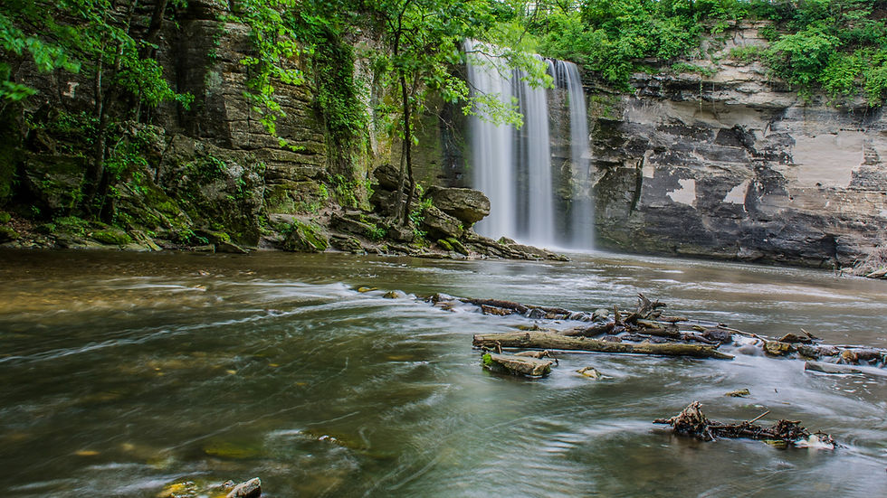
Minnemishinona Falls drop 42 feet over a rock ledge. The waterfall is located five miles west of Mankato on Judson Bottom Road.
The byway now begins its westward trek, starting five miles west of Mankato at Minneopa State Park. It’s on the southside of the Minnesota River, directly across from Minnemishinona Falls. The name Minneopa, "water falling twice," comes from the Dakota language and refers to the park’s double waterfall. Follow Bison Drive Road through 325 acres of range to see the resident herd of about 40 bison. There’s also the 1864 Seppmann Windmill that could grind 150 bushels of wheat into flour on a day with good wind. However, it’s been missing arms since an 1890 tornado. Camping, fishing and birding are also part of this park’s experience.
Minneopa’s windmill was built by Louis Seppmann, a German native. From the state park, it’s 22 miles to the next charming community, New Ulm, founded by German immigrants in the 1850s. Considered the most German town in Minnesota, there’s German food, German shops and a German brewery. In fact, August Schell is the oldest brewery in Minnesota and the second oldest family-owned brewery in the U.S. Throughout the day in Schonlau Park, the 45-foot-tall Glockenspiel’s bells chime while 12 figurines rotate on a circulating stage. Stop by the Brown County Historical Society to learn more about New Ulm’s colorful heritage. The museum’s distinct German Renaissance-style building is itself a gorgeous showpiece.
From New Ulm, it’s 17 miles northwest to Fort Ridgely State Park. Set in scenic rolling hills, the park has camping, trout fishing, horseback riding and hiking through prairies and woodlands. History is the other big draw. Completed in 1855, the fort’s population numbered some 300 soldiers and civilians. During the US-Dakota War of 1862, it withstood two major attacks and later became a training ground for Civil War recruits. Fort Ridgely’s time as an active military post ended in 1872.
From Fort Ridgely, go another 17 miles northwest to Lower Sioux Agency State Historic Site near Morton. Managed by the Lower Sioux Indian Community, this marks the first battle of the US-Dakota War of 1862. The history center has exhibits on Dakota history, culture and the events that led to the war. Trails lead to the restored 1861 stone warehouse and the site of the Battle of Redwood Ferry.
Redwood Falls is another 11 miles west. It’s well-appointed with fuel, lodging, restaurants and pharmacies. The prettiest spot in town is also one of the biggest in the state. Nicknamed "Little Yellowstone of Minnesota," 256-acre Ramsey Park is Minnesota’s largest municipal park with camping, a zoo and the lovely Ramsey Falls. The Redwood Falls Golf Club is adjacent.
Another natural beauty lies 40 miles northwest of Redwood Falls. With grasslands, wetlands and woods, Upper Sioux Agency State Park has a diverse terrain for hiking, birdwatching and horseback riding. There’s camping, including three canvas tipis.
For something completely different, go eight miles west of the state park to the self-guided Fagen Fighters WWII Museum. Located south of Granite Falls, it houses a large collection of fully operational aircraft, including fighters, bombers and trainers. There are also jeeps, a tank buster, bulldozer, motorcycles and artwork.
It’s just another seven miles south on Minnesota State Highway 23 to Minnesota’s Machinery Museum in Hanley Falls. The stories of generations of farm life are told through implements, tools, tractors, gas engines and rural art in four large buildings.
Heading back to the northwest again, the byway leads to Montevideo with a brewery, fast food and Historic Chippewa City where 24 buildings on 20 acres replicate a late 1800s village. The preservation project began in 1965 with a one room schoolhouse and has grown to include a church, bank, general store, blacksmith shop, hat shop and log cabins.
Driving northwest out of Montevideo, follow the Minnesota River 12 miles to the start of Lac qui Parle Wildlife Management Area, a vast 33,000-acre expanse of rivers, lakes, wetlands, woodlands and prairie, vital to the Dakota for thousands of years. Set up camp at Lac qui Parle State Park and then canoe, kayak and hike. Fishing and hunting are primary activities, too. The name is a French translation for what the Dakota called the "lake that speaks." In spring and fall, thousands of noisy migratory Canada geese and other waterfowl stop at Lac qui Parle. For history buffs, check out the nearby Fort Renville Historic Site, an 1820s fur trading post and Lac qui Parle Mission, established by Christian missionaries in 1835. The poet Robert Bly grew up in these parts, and 16 miles west in Madison the Lac qui Parle County History Center displays his study along with a furnished 1870s log cabin, 1880s schoolhouse, 1933 gas station, wagons, farm machinery and tools.
As the byway approaches South Dakota, 35 miles northwest of Lac qui Parle State Park is Big Stone National Wildlife Refuge. Drive or bike the five-mile Auto Tour Route through wetlands, woodlands, prairie and granite outcrops. A few miles farther and the highway reaches Ortonville. Then, it skirts the eastern shore of 26-mile-long Big Stone Lake, the source of the Minnesota River. Big Stone Lake State Park has waterside camping, boating and fishing for bluegill, northern pike, perch and walleye. It’s another 25 miles to the byway’s end in Browns Valley, on the South Dakota state line.


Comments