
Utah’s Colorado River Scenic Byway features massive sandstone fins, pinnacles and buttes
- Greg Phillips
.JPG/v1/fill/w_320,h_320/file.jpg)
- Jan 28, 2025
- 3 min read
Updated: Apr 30, 2025
This byway is one of our choices for Utah’s Top Scenic Byways, as listed in our Utah section.

The Colorado River Scenic Byway is a segment of the Dinosaur Diamond Prehistoric Highway but it needs to be considered separately, too. While most travelers arrive in Moab via US 191, a far more inspiring drive is Utah State Highway 128. It starts near Cisco, an almost ghost town just off I-70. From Green River, head east 43 miles on I-70 to exit 204. If you’re coming from Fruita, Colorado, it’s 47 miles west on I-70 to the exit.

I-70 to exit 204 then south on UT 128 to Moab, including short detours
Distance: 80 miles / 114 km
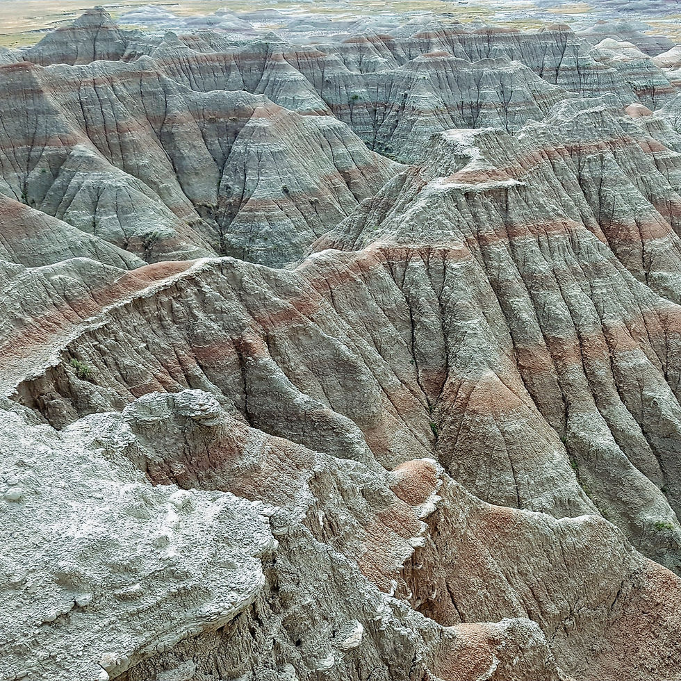
Driving south through a harsh, barren landscape, the desert suddenly gives way to the Colorado River and a deep red rock canyon that water, wind, rain and ice continues to carve. Several appealing campgrounds and trails are found along the drive including two must-hikes to Titan and Morning Glory Arch.
About 23.5 miles from I-70, look for the turnoff to Fisher Towers on the left where a two-mile gravel road leads to a parking area. Fisher Towers are massive sandstone fins and pinnacles. At 900 feet high, Titan is a favorite with climbers. This moderate hike winds along the base of the towers and it can get really hot so bring plenty of water and sunscreen.
Back on UT 128 and continuing west, you can’t miss Castleton Tower looming on the left. If you hiked Fisher Towers, you would have clearly seen this striking formation: a stone needle standing tall atop an imposing butte. With countless film, TV and commercial appearances, Castleton Tower is perhaps the world’s most famous desert pinnacle. From the Fisher Towers turnoff, it’s about 5.5 miles to Castleton Road where a short drive provides closer views.
From the Castleton Tower turnoff, the drive tightens as UT 128 moves west, with canyon walls to the left and Colorado River to the right. Look for rafters, kayakers and standup paddleboarders navigating the rapids. Some 11 miles from Castleton Road, Grandstaff Canyon is the next incredible hike where a trail follows a creek and then veers into desert before ending at Morning Glory Arch, the sixth longest natural rock span in the U.S.
The “upper” part of the Colorado River Scenic Byway finishes when it meets US 191 as it exits the canyon just north of Moab. If you continue three miles north on the four-lane highway, look for UT 279 to the left. This is the start of the Potash – Lower Colorado Scenic Byway.
Climbers love the section called Wall Street with cliffs like Manhattan skyscrapers. Signage indicates petroglyphs and dinosaur tracks. You’ll be amazed at how easy they are to spot from the main road once you know where to look. Nearby Arches National Park and Canyonlands National Park are frequently crowded, sometimes to capacity. So, this byway offers alternative hikes, including the two-mile roundtrip trek to Bowtie and Corona arches.
The byway officially ends by potash ponds at a watercraft launch into the Colorado River. It’s worth noting the pavement turns to dirt as the road continues to follow the river into Canyonlands National Park. But this route is only suitable for high clearance 4WD vehicles. Back in Moab, the town has undergone explosive growth with lodging, resorts and restaurants in every price range.

Comments